
Construction site drone survey updates.
If you are a construction site manager needing to keep progress on the development of your projects, we are able to offer regular drone site updates. We can create 2D geo-referenced mapping, and also 3D modelling, which also gives elevation mapping, distance measurements, area measurement and volume. We can offer 360 degree photos and aerial photography and video. This can be a great alternative to a lidar drone surveying company.
Drone photogrammetry surveying.
We are able to create maps using drones covering any size area. The flights are planned with the drone covering the area in question at various heights and angles to allow us to create accurate geo referenced 3D and 2d maps, point clouds, 3D meshes and elevation models

You also have a cloud based timeline and are able to compare with a slider between time points. You can accurately measure distances, areas and volumes.. these standard maps use the normal gps system, and accuracy should be within a meter but this varies on gps signal strength… we are able to offer 1-4cm accuracy using a more advanced RTK drone that costs extra. These kinds of surveys are the most time consuming and involved around over an hour of flying on site.. flying right to the boundaries of you plot which might be a consideration. They also need to be done in certain conditions to come out the best.. cloudy days are best with very low winds..
360 Degree photos:
Another option we now have is 360 degree photos… which can be taken from the same point every month and allow you to move the view around… again… these only work when winds are low and are best when it is cloudy…
Drone Mapping Services.
We can offer aerial photos and videos… we are able to take the drone back to the exact same gps coordinates and height… the same yaw angle and camera pitch angle to allow is to almost create a time lapse.. The advantage of normal videos and photos are that these can be flown in the most varied of conditions.. so if you want things done for a meeting or report they are lease likely to be stopped by high wind. Which in the UK is fairly common…
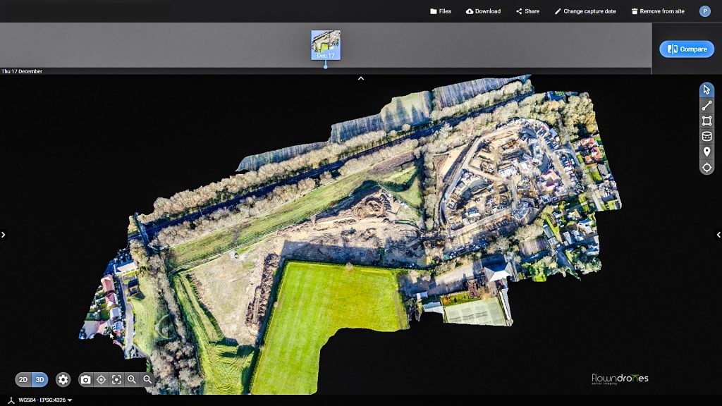
With 2D models you are able to use a slider to see before and after images.

If you are a site manager or anyone wanting to track the progress of large developments for progress or investor reports, here at flowndrones we can offer various options using drones. As the cheesy saying goes if you can’t measure if you can’t manage it. As you can see on the screen here, we are able to create 2d maps and 3d models, using drones, covering pretty much any area size, the flights are pre planned, with the drone covering the whole area at various heights and angles, to create accurate geo referenced maps and models.
So shown on the screen, we have the 2D options, and you can see the site in question overlaid on an older map. If we zoom in on that you are also able to compare the site at different dates using the slider in the top of the screen, click the compare button, and then use the slider, which you can slide between the time points, to show progress of the site between the dates. So, you can see how the site looks now and how it used to look.
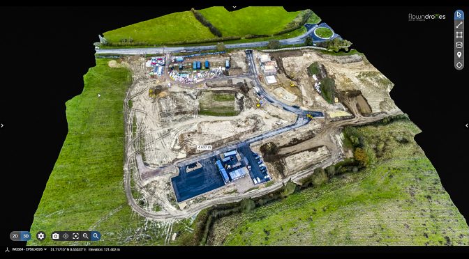
If we go into the 3d options, we can create 3 models as you can see here. On the left menu here we have various options, we have a textured mesh, elevation plots, which show the various elevations as different colours, if you look at the bottom left of the screen you have the GPS position and the elevation above sea level I believe, at this site in question we are quite high at this end and it slopes down towards the far end. We are also able to create 3d point clouds which are more involved for the computer and take it a time to render.
We can also zoom in and have a good look around, they are more accurate from higher up, but if you want more accuracy lower down, the drone can be flown at lower heights, this model show here, was created from flights at 300 and 400ft.
This software is also cloud based so you can login at any location yourself, or share it amongst a team. The 2d maps and 3d models are geo referenced so they are accurate, which allows you the following tools on the righthand side here. You can measure distances and elevations, areas, and volumes. So, if you have temporary features onsite, which you want to keep an eye on or measure or check, without the expense of a full lidar survey, these can be a great much lower cost alternative, all be it with slightly less accuracy. For example, if certain parts of the site are supposed to be a certain distance from outside roads, we can use this distance measuring tool, to check the distance from this heap to the outside. So for example if we check that heap, the distance to the outside here is 100 meters, or for example the distance of this temporary road, you can quickly use the distance measuring tool., and we can see it is 93 meters long.
This also gives you elevation, so if you look at the top of the pile, we can see on the bottom left of the screen the GPS position and elevation above sea level, and we can see the top of the pile is around 87 meters, it drops down there to around 85, and then at the bottom, 83 and then to this side down to 80. This can be really good for checking the height of things.
We also have the area tool here, so if we take for example this temporary car park, we can quickly check that it is the right size in square meters. Then we also have the volume tool, so if we look over here at the heap, we can quickly trace around it, and it gives us an idea of the volume of mud here in the heap. As you can see there here there are over 4000 cubic meters of earth here.
I have put a link here to research done on the accuracy of these maps, as they are created by GPS. The maps we are looking at here are made with a drone using GPS to log the positions, so we are looking at accuracy of less than a meter, we can see if we overlay it over other maps everything lines up very well, but the accuracy will depend somewhat on the signal strength of the GPS in the location of the site. We are also able to offer higher accuracy using more advanced and expensive RTK drones, which claim 1-4 cm accuracy, and are a more expensive service. But it all depends what level of accuracy you need.
These surveys are the most involved and usually involve around an hour flying time on site. They also need to be done in certain lighting conditions to come out the best, either clouding, or a little sun, which can give the map a little depth, but is not as good for the 3d model. So cloudy days are the best with very low winds as well.
The next option we have which are simpler, are the new 360-degree photos, which can be taken from the drone each month in the same GPS position and height, and they allow you to move around, and have a look around the site just from one position, they again have to be flown on low wind days, on high wind days they will not work as well… you can zoom in and out. They are not as accurate as the photogrammetry models, but are quicker and easier to make.
We can also offer aerial photos and video. We are able to take the drone back to exactly the same position each month, using the same GPS position and height, and yaw angle of the camera and its pitch (which is the camera position) to capture near exact same position photos. From this we can create an almost time lapse as the site develops. The lighting conditions need to be the same frame for it to really work well, but can be great for progress tracking.
The joy of the photos and video is they can be captured in the strongest winds, so if you have a deadline, or need the photos done asap, these can offer more flexibility. For more information on this, please contact us.